The highest situated village in Ukraine is Vypchyna, Chernivtsi Oblast, located at an altitude of 1100 meters above sea level.
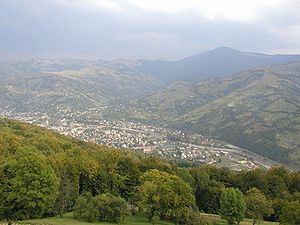
The highest mountains in Ukraine can be found in Rakhiv. The average altitude of the city is 820 meters above sea level. Rakhiv holds another record; it has the biggest vertical drop between the streets that makes 600 meters: 400 meters from the lowest one, 1000 meters to the highest one.
The highest situatedworking place is a research facility –a biostationarof Lviv department of the Institute of Botany of National Academy of Science of Ukraine, located inPozhyzhevskavalley (1429 meters above sea level). It includes a weather station and an avalanche research station. The institution was built in 1899.
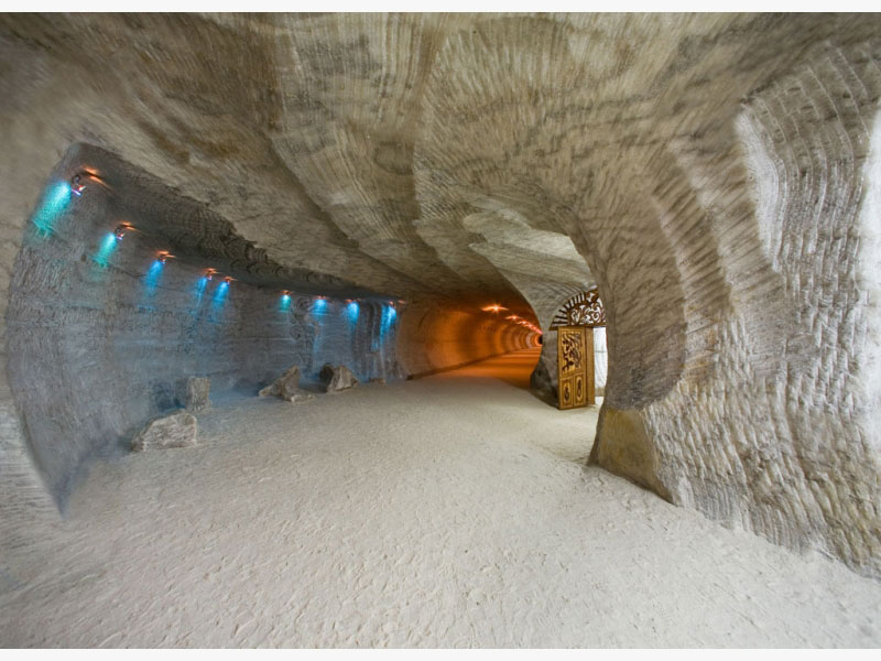
The deepest situated hospital is in Solotvyno village, Transcarpathian Oblast. Over 200 years, salt of superior quality has been minedthere. In 1968, the members of Uzhhorod department of Odessa Scientific-Research Institute of Balneologydecided to use the microclimate of Solotvyno mines for treating bronchial asthma. The allegro logical hospital that accommodates 250 people was opened there. The underground wardsfilled with highly dispersed salt aerosol are located at a depth of 206 and 282 meters in a thick salt layer. The duration of one treatment session is about two hours for 30 days. Patients descend to the salt wards via the elevator. The conditions, which are impossible to create on the ground, are the following: constant temperature (23 degrees), humidity (up to 40%), salt-saturated atmosphere(10 mg per 1 cubic cm), absolute silence, completely non-allergic environment, and the number of microorganisms in the air is 5 times lesser than in the most sterile operating room.
The highest situated resort is in the village Vorokhta, Ivano-Frankivsk Oblast. Its altitude makes 850 meters above sea level. There are two tuberculosis sanatoria “Hirske Povitrya” (“Mountain Air”) and “Vorokhta”.
The first geological map of Ukraine was the map of the Carpathiansdrawn by S. Stashyts in 1809.
The most significant paleontological finding in the territory of the Carpathian Mountains is the remains of fossil fauna in the village Starunya (now in Bohorodchany district, Ivano-Frankivsk Oblast). In 1907, there were accidentally found the remains of animals of the late glacial period. Near the stream Lukavets Velykyi, in ozocerite mine, at the depth of 12.5 meters, there were found the remains of a mammoth, a hairy rhinoceros, a giant deer, and different species of fossil birds and amphibians. Apparently, salt, ozocerite, oil solution, and oxygen-free conditions of the ground helped to preserve the ancient animals. With the help of radiobiology, it was determined that the rhinoceros had been buried there for about 23 255 ± 775 years. Speaking about the way the animals appeared there, it is most likely that theUpper Paleolithic people inhabiting the current Starunyaarea were hunting them. Theytricked the animals into the swamp where they died. The results of a thorough study of the findings made in 1907 and 1929 by E. Nezabytovskyi-Liubych, M. Lomnytskyi, and other researchers were published in several monographs and special periodical, titled “Starunya.”
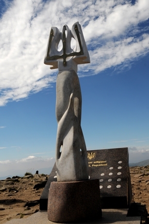
The highest situated construction is a 5 meter high monument on Hoverl a mountain erected in 1996. It features the state symbols:
ablue and yellow flag and a trident.
The highest situated constructioncan be found on the top of Pip Ivan mountain. It is a stone building that once used to be a meteorological-astronomical observatory. Its grand opening took place in the summer of 1938. The astrograph with a 33 cm lens diameter was the main astronomical tool used in the observatory.
During World War II, this building, also known as the “White Elephant”, fell into disrepair and is waiting to be repaired one day.
The highest situated hotel is “Berkut”, which can be found on Yablunytsya mountain pass. It is located at an altitude of 931 meters above sea level. The hotel was built in 1968.
The longest railway tunnel is situated between Skotarskeand Beskyd. Its length is 1747 meters. The tunnel was built in 1887.
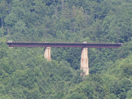
The longest viaduct is a railway bridge between Volovets and Beskyd. It was built in the mid 1880’s.It is 33 meters high and 270 meters long.
The world’s largest stone railway bridge can be found in Vorokhta village. It was built in 1895. It is 130 meters long and 65 meters wide.
The highest situated sports facility is located nearby village Yasynya at an altitude of 1450 meters. It is a sports-training center Drahobrat. This village is a unique Carpathian valley rich in snow. The training season here begins in December and ends in April. Interestingly, in 1993, ski training season lasted until July 15!
The largest among high situated sports facilities is a comfortable training center Tysovets which is located near Skole town, Lviv Oblast, at an altitude of 1000 meters above sea level. It is designed to accommodate 450 people.
The highest situated railway station is “Beskyd” built at an altitude of 790 meters above sea level.
The longest wind instrument is trembita, which is a conical wooden tube without side openings thatreaches 4 meters in length. It is mostly popularin Hutsul, Bukovyna, and Boikivshchyna regions and is still used in the villages for signaling or information exchange. The range of trembita is 2.5 octaves; its sound can be heard for more than 10 kilometers.
The Forest Museum can be found in the Transcarpathian village Ust – Chorna. The collected exhibitsgive information about the difficult, dangerous, and yet the most popular occupation in this land of mountains and forests. Here, one can find an interesting collection of vehicles of all times designed for forest works. There are drays, tractors TDT-40, and trestles for wood loading. Among the exhibits, there are nursery gardens of young fir trees, maple, and beech. Besides, one can find trees of unusual shapes formedby lightning strike or strong winds.
The biggest plateau is situated in Chyvchyny mountains at an altitude of 1750 meters above sea level. It is a flat top of the mountain Palenytsya.
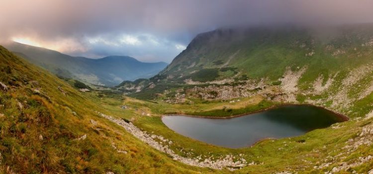
The highest situated lake is Brebeneskul, located on the slope of the mountain Hutyn-Tomnatyk at an altitude of 1801 meters above sea level. It is 134 meters long and 44 meters wide; its area covers 4000 square meters, and its maximum depth is 2.8 meters.
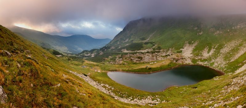
The largest mountain lake is Synevyr in Mezhyhirya district of Transcarpathian Oblast (Tereblya basin). Its area covers 7 hectares, and it is 24 meters deep. People also call it the “Blue Eye” or “Carpathian Ritsya.” A strong earthquake or, perhaps,many centuries of weathering caused a landslide of rocks that dammed up themountain stream and formed a lake at an altitude of 989 meters above sea level.
The highest situated mountain swamp is located in the anticline between Breskul and Pozhyzhevska valleys at an altitude of 1800 meters above sea level. This subalpine hollow mud incirque glacier was formedas a result of lake swamp. These swamps also include the ones in Ozerne grotto (1750 meters) and at the foot of Brebeneskul mountain (1700 meters).
Hanging swamps are considered to be the most unusual swampsthat are situated on the slopes of the mountains. The biggest among them is Hlystove swamp located on the southern slope of Hrynyavy mountains at an altitude of 1450 meters above sea level. It is very rich in flora: there are, for example, 17 species of aspen. This swamp has been a natural landmarkof national importance since 1975.
A cave with transparent walls. Nearby Mala Uholka village in Tyachivregion, Transcarpathia, close to Pohar mountain, there is a karst cave. It was formed in Jurassic marble limestones and created by two perpendicular cameras 5 and 20 meters long. The walls are covered with a milky-white transparent calcite with greenish drop stones that look like beautiful flowers. The cave has a great scientific and aesthetic value.
Pearl Cave.2.5 kilometers from Mala Uholka village, at the watershed of the two rivers Mala and Velyka Uholka, there is a karst cave formed in Jurassic marble limestones. It is an example of interstitial waters influence on slightly soluble carbonaceous rocks. Apart from stalactites, numerous calcite balls, resembling pearls,have appeared on the walls, hence the name.
The Enchanted Valley. In Irshava region of Transcarpathia, in the upper course of Smerekiv stream, there is a surprisingly picturesque place – the Enchanted Valley or Smerekiv Stone. The weathering has given a wonderful look to its numerous 20 meters high cliffs, composed of light-gray calcites lying among hydrothermally altered volcanic tuff. This state reserve of 150 hectares attracts many tourists annually.
The Narcissus Valley nearby Kireshi village, Khust district, is the only place in Ukraine with the wild growing narrow-leaves white narcissi. They resemble garden narcissi, but the flowers are larger sometimes reaching 10 cm in diameter. The picturesque valley of 80 hectares, covered with a carpet of flowers and surrounded with mountain slopes, is a natural landmark.
The Cut Stones tower above the mountain pass Nimchych at the boundary of Putyla and Vyzhnytsyaregions in Bukovyna. The stones are formed from broken layers of Yamne sandstone put over one another, and reach 30 meters in height. A rare form of weathering has been formed in this group of caves. It created a gate, about 2 meters high, which gave the name to these rocks.
The Stone Gate. Near Mala Uholka village, Tyachiv region, Transcarpathia, in the valley of Mala Uholka, there is an unusual rock, which makes a type of karst bridge in marble limestones of the Jurassic period, where karst processes created a passage 10 meters wide and3 meters high. This geological landmark has not only educational but also scientific value,being the original form of karst.
The Lovers Rocks. On the outskirts of Kostylivka village, Rakhiv region, two steep cliffs up to 20 meters high rise above the opposite banks of the Tysa River. There are two crosses on the tops which, according to the legend, were put in memory of the tragic death of two lovers, Ivan and Marichka, whose parents were against their marriage. Desperate Marichka threw herself down from the cliff and died. Overwhelmed with grief, Ivan also threw himself from the top of the cliff on the opposite bank of the Tysa.
Rocks with “hieroglyphs” can be found nearby Serednie Vodyane village, Rakhiv region, Transcarpathia. On the eastern slope of Buzhora mountain, there are sediments of Miocene age presented by the layers of sandstone, argillite,and siltstone. On the sandstone surface, there remained numerous wave marks resembling hieroglyphs that indicate heaving of the ancient sea.
The windiest place in the Carpathians is Pozhyzhevska valley. The wind speed here reaches 15 meters per second (54 km/h), and blows, on the average, 120 times a year.
Pozhyzhevska valley is also the wettest place in Ukraine: its annual precipitation reaches 1593 mmHg.
The most snow-clad village is Ruska Mokra in Transcarpathia. A long-lasting snow cover lies here 110 days a year, averagely. It is caused by specifics of a village location between mountain ranges that significantly hide its territory from direct sunlight.
Village Mizhhirya receives the biggest amount of solar radiation in the Ukrainian Carpathians. It is 2 145 mJ/m2, while in Crimea it is 5 165 mJ/m2.
Starunyavillage is full of natural surprises. Besides other attractions, it is the most seismically active zone. Near this village,there is a small plot of land (1.5 km2) called Chudo-Starunya, whichpresents a wonderful combination of different stratigraphic, mineral and petrological, hydrological and neotectonic features. High seismic sensitivity is obvious from the appearance of cracks, gaps, rifts and small waterfalls, mud volcanoes, active gassing dynamics, as well as uneven growth – about 1meter in seven years. Chudo-Starunya reacts to earthquakes that occur within a radius of 3-6 thousand kilometers in Romania, Italy, Germany, Iraq, the Caucasus, and even Central Asia. This underground “barometer” is a unique place to study the features of earth dynamics, the regularity of mineral resources, and earthquakes predictions.
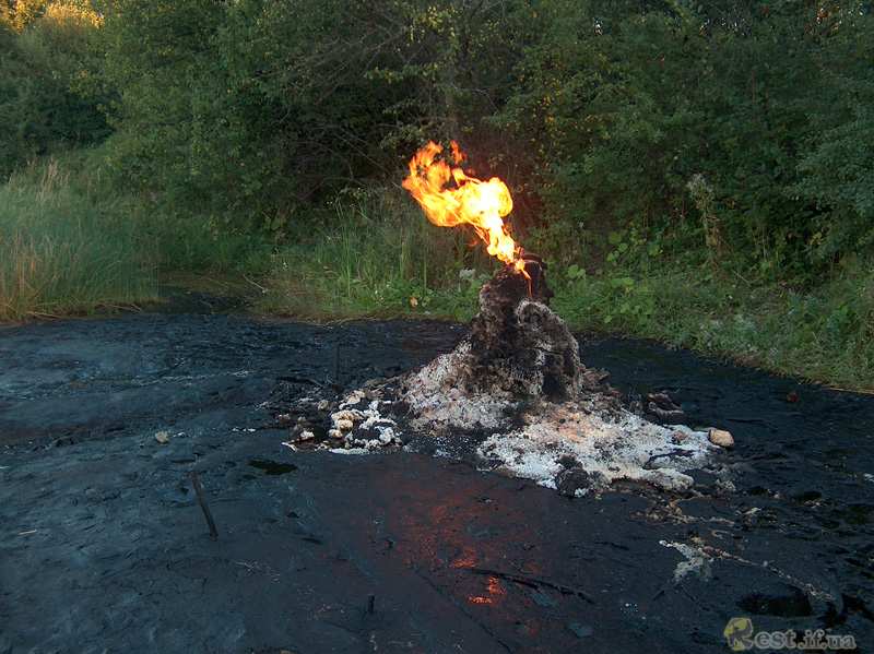
Nearby Chudo-Starunya, there is the biggest active volcano. On the western bank of the river Lukovytsya, close to this village, geological rocks form a complex tectonic trough, on top of which there is a volcano with a 3 meters long neck and 10-60 meters long loam sediments. It appeared in 1977 as a result of the earthquake in Romania, and counts 8 craters and 12 non-permanent micro-craters that emit gas, water, loam pulp, as well as oil or its differentials. Distant earthquakes sometimes cause cracks in the ground 0.5-3 cm wide, which close in 3-5 days.
One of the biggest floods in the Carpathian region was the one in 1947-1948. At the end of December 1947, the snow layer accumulated in the mountains reached 30-50 cm; sudden warming and rains caused the disaster. As a result, the rivers Tysa, Tereblya, Teresva and others overflew the banks flooding nearby villages Hust, Vylok and many others.The big areas of winter crops were destroyed.
The biggest flood caused by rains and downpours occurred on August 30-31, 1927, in the Carpathians. The eyewitnesses told that the incessant downpours reached 315 mm of precipitation. The water rise in rivers Stryi, Svicha, Limnytsya, Bystrytsya Solotvynska and others was catastrophic; it reached its peak already in 3-4 hours. Many villages were flooded in the valleys of the rivers (Sambir, Mykolayiv, Stryi); turbulent streams demolished hay and reaped harvest.
One of the most tragic floods of our time occurred in December 1992 in Transcarpathia, at the river Uzh. High mountains, steep river slopes, frequent intense rains, sudden warming, fast snow melting, ruthless deforestation – these and other factors caused 5 million karbovanets damage at that time. Sadly, 17 people died in the flood, 200 families lost their shelter, 4 thousand houses were subjected to repair, and 30 thousand hectares of arable land were deluged. Among other terrible floods, the one that occurred in 1998 caused 500 million UAH damage and 17 deaths,while the flood in 2001 caused 10 million UAHdamage and the maximum water level in the river reached 13 meters.
The Carpathians are naturally the most dangerous living area in terms of debris flow; it counts 271 debris sites in the basins of the rivers Tysa, Dniesterm and Prut.
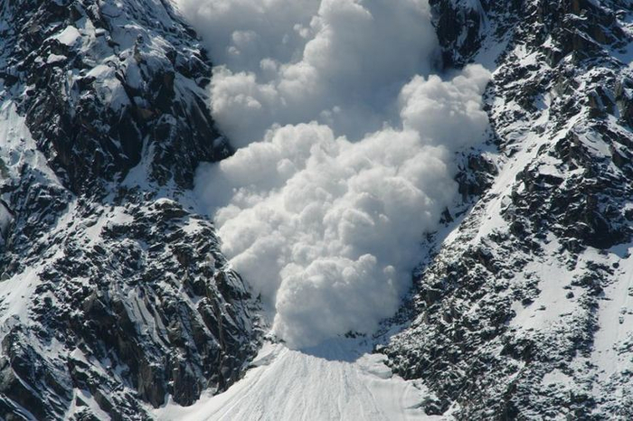
The Carpathian Mountains are also a dangerous avalanche trigger zone. About 1 thousand avalanche sites have been recorded there. Snow masses move from a couple of meters to 2-3 kilometers at a speed of 1-10 to 80-100 meters per second. The amount of snow avalanches in some areas makes up to tens and hundreds cubic metersto 1 million, and hasan enormous destructive power. According to avalanche researcher V.F. Hrytsenko, the most often, the avalanches occur in March (254 registered) and February (104), and the most rear in November (5).
The largest avalanches in the Carpathian Mountains, recorded in the last century,occurred in 1968 in Svydovets, mountain Stih: 300 000 m3. In 1988, in Borzhava, the amount of snow of several avalanches exceeded 500 000 m3, while two of them made 800 000 m3. One of them destroyed 16 hectares of the forest. The avalanches traveled3.5 km distance.
Pozhyzhevska mountain valley is very rich in hail. It hails here 13 days a year.
The stormiest place in Ukraine is Selyatyn village in Bukovyna. Storms occur here 45 days in a year. In Velykyi Bereznyi, it makes 43 days, in Rakhiv–41 days per year. Selyatynis also known as the village where the most long-lasting storm occurred. In 1948, it began raining on June 10 at 15:30 and ended on June 12 at 4:30; it lasted for 37 hours in total.
The fastest growing plant is not a bamboo but a mushroom Phallus impudicus (also known as the common stinkhorn) which can be found in the Carpathian forests.It grows by leaps and bounds: 5 mm in 1 minute which is twice faster than bamboo.
The mushroom with the highest seed count is Calvatiagigantea (also known as the giant puffball) which contains up toseven trillion spores.
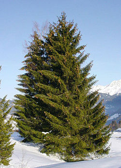
The oldest tree in the Carpathian forests is fir (spruce). It originates from the Cretaceous period of the Mesozoic era. Yet, at the dawn of humanity, it was used as a healing plant due to its phytoncide-antibacterial properties. In Ukraine, there are two species of wild spruce–common spruce and mountain spruce.
A tree with the longest life span in Ukraine is Taxusbaccata (also known as yew). This plant can reach the age of 4 thousand years. In the past, it was widespread throughout the whole forest zone of Europe, however, it was cut down because of its fine wood: for this reason it is called “royal” or “non-decaying” tree. Yew trees grow in Knyazhdvir reserve nearby Kolomyya village, Ivano-Frankivsk Oblast, which covers the area of 206 hectares. Among the most long-lastin trees, there is European cedar: it lives up to 3 thousand years.
The tallest tree is Pinusmugo (also known as mountain pine) which can be found on the slope of Pip Ivan mountain, at an altitude of 2010 meters above sea level. This tree is unpretentious;it has wide ecological amplitude, can grow on dry rocky cliffs and wild land with poor soil layer. The tree height varies from 20-30 cm to 2-4 meters.
The tallest tree record goes to Larix decidua (also known as European larch) in Rakhiv. When it was cut down at the age of 140 years, it was 54 meters high.
The smallest tree growing in Ukraine is Salix retusa (or retuse-leaved willow). It is 12-15 cm high and can be found in wet limestone rocks in the alpine zone of the Carpathians, in particular, on Blyznytsya mountain.
Джерело: cikavo.com.ua